

A publication of the Archaeological Institute of America


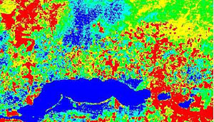 This image from the LANDSAT 7 satellite shows thermal bands. Comparing these different temperatures is one way to locate caves using remote-sensing techniques. |
Cave sites are particularly important to archaeology because they can contain material in primary context, that is in the same place where ancient peoples deposited it. Looters are in search of treasure to sell on the black market, and in the course of their activities they disturb the primary context of archaeological sites. This is a substantial problem in caves because many of them have magnificent artifacts, most of which are fully intact and rest upon the surface in full view. It is important to find cave sites before they are disturbed, but as simply re-locating known caves in the jungle can be a monumental task, finding new and undisturbed caves can be nearly impossible.
|
Field Updates: See also Reconnaissance in the Chiquibul. | Our project will test the potential of remote-sensing techniques for revealing cave sites in Belize. Since the late 1960s, remote sensing has been used in Mesoamerica to locate agricultural features such as raised fields and canals. These early efforts employed aerial photography and radar. Remote sensing has also been used to find surface archaeology utilizing more advanced platforms. Remote sensing in the context of cave research refers to the utilization of satellite images of the earth's surface. Satellites record a broad range of electromagnetic radiation reflected from the earth, which is useful for differentiating between types of land cover (water, infrastructure, agriculture, wetland, and forest) and thermal gradients. |
The interiors of caves remain at a constant temperature of about 60 degrees. This is in sharp contrast with the outside temperature, which can reach 100 degrees on hot days. Most of the caves are dry but some have streams running through them year-round. The caves with water running through them are generally a bit colder than those without. The water that runs through the caves is much colder than that in the rivers, and these streams maintain the cold temperatures for some distance outside the caves. These temperature differences may be detectable by thermal bands through the jungle canopy.
The observation of vegetation types in close proximity to cave areas will also be important for this project, as it is possible that certain types of vegetation may grow near cave entrances. The selective diets of bats and other troglophilic creatures may select for certain species over time within close proximity to caves. With a good data set the classification process could yield a spectral signature that can be labeled "cave."
The combination of ground testing in Belize and the evaluation of satellite images will determine the usefulness of remote sensing for cave research. If successful, remote sensing would make the discovery of subterranean archaeological sites more efficient. The possibility that remote-sensing techniques could reveal caves that have not been explored since the time of the ancient Maya makes this research project even more exciting.

|
Click here for a more detailed account of the procedures and equipment being used in WBRCP's remote-sensing project. |
Remote-sensing research in 2000 was supervised by Cameron Griffith, co-director of the Western Belize Regional Cave Project and a Ph.D. candidate at Indiana University. The research team consisted of Rusty Peterson, Indiana University; William Pleytez, Chechem Ha Lodge, Belize; and Bruce Minkin, M.D., North Carolina Hand Surgeons Associates. This research is being conducted with assistance from Tom Sever and Dan Irwin of NASA. The project has received funding from the Honors College at Indiana University.
How to cite this page:
Griffith, Cameron. "Remote Sensing in Cave Research." Archaeology. Archaeological Institute of America. 15 Jul. 2000. Web. (Date of access). https://archive.archaeology.org/online/features/belize/remote.html.
Intro | Trip to Xibalba | Interview | Field Notes | Student Journals | Remote Sensing | Q&A | Map
© 2000 by the Archaeological Institute of America
archive.archaeology.org/online/features/belize/remote.html
Advertisement

Advertisement


