

A publication of the Archaeological Institute of America


| |
|
"Under City Hall Park" February 25, 2000 |
|
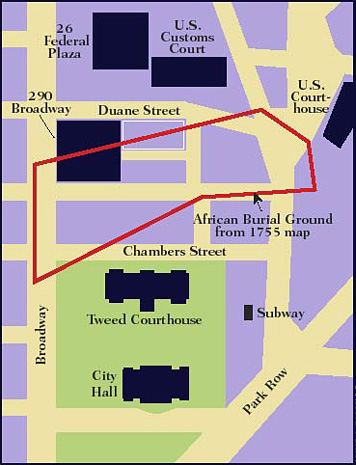 |
| Map shows modern street grid, City Hall Park area (green), and approximate boundary of the eighteenth-century African Burial Ground. (North is toward the top of the map.) White rectangle denotes portion of 290 Broadway office complex modified after intact burials were found there. Excavations in 1999 during renovation of the park encountered human remains in the park's northwest and northeast corners and east of the Tweed Courthouse. (Lynda D'Amico) |
© 2000 by the Archaeological Institute of America archive.archaeology.org/online/features/cityhall/captions/streeetmap.html |
Advertisement

Advertisement


