Location, Location, Location
by Heather Pringle
November 7, 2008
 This week, the readers of Craigslist in St. Louis, Missouri, encountered an extremely unusual property listing in the online real-estate section. Tucked amid hundreds of ads written by desperate homeowners caught in the subprime mortgage catastrophe, the posting offered bargain-hunters a different kind of deal: a “Prehistoric Native American Mound with Views of the Mississippi (St. Louis East of Grand)†–all for $400,000.
The ad was composed in Realestatish, that language peculiar to those who sell fixer-uppers and other questionable abodes to unsuspecting buyers.  “You won’t believe the view and the history that comes with this absolutely unique property!â€raved the ad. “Sugar Loaf Mound is truly a one-of-a-kind river front property, offered to a new owner for the first time in over half a century. With St. Louis known as Mound City, this property includes what’s thought to be the last remaining prehistoric Native American mound in St. Louis overlooking the mighty Mississippi River, speculated to be part of the Cahokia civilization.â€
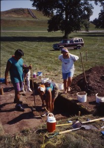
I didn’t know whether to laugh or cry. I’ve never seen an archaeological site described with such salesmanship, and it took some getting used to. By then, however, the sadness had set in. I once flew to St. Louis just to see Cahokia, a giant earthen maze of more than 100 prehistoric mounds that lies just 15 minutes east of St. Louis. Cahokia is now a UNESCO World Heritage Site. At its peak in the 11th century, Cahokia boasted a population of 10,000 to 15,000 people, and its rulers likely commanded as many as 85,000 people in the surrounding countryside. Â
In many ways, Cahokia was a perfect illustration of the real estate adage, “Location, location, location.â€Â It lay near the junctures of three of North America’s most important prehistoric trade routes—the Mississippi, Missouri and Illinois Rivers—giving Cahokia a commercial edge over rivals. And it bordered a wide array of ecosystems, from the Eastern Woodlands and the Ozarks to the Great Plains.  This meant that Cahokia’s inhabitants could pick and choose from a vast range of wild foods, quite apart from the corn they cultivated.
The rulers of Cahokia were clearly an ambitious lot. Like their Maya counterparts, they encouraged their subjects to build massive public monuments. The greatest of these, Monks Mound, occupies 15 acres at Cahokia and stands nearly 100 feet high. It is the largest prehistoric edifice north of Mexico. But here’s why Cahokia languishes in obscurity, while we all know about places like Tikal. Unlike the Maya to the south, the people of Cahokia created their most spectacular public architecture out of earth, rather than stone.Â
Western civilizations have a long tradition of building in stone, from the trilithons of Stonehenge to the arcades of the Colosseum. As a result many Westerners prize stone architecture, turning up their noses at other forms.  But I learned very early in my career as an archaeological journalist just how ingenious more ephemeral forms of architecture could be. The tipi, a portable home of animal hide and wooden poles,  looks dead simple to build. But it is incredibly energy-efficient. It is easily heated by a small wooden fire and, as a veteran Alberta archaeologist once told me, it remains warm and comfortable inside even when outdoor temperatures plunge to -50 degrees.Â
So I am sincerely hoping that whoever steps up to the plate to buy Sugar Loaf Mound, which lies outside the protected Cahokia site,  will remember that it is much more than a real estate purchase. It is a part of all our collective past, and one very worth saving.   Â
Comments posted here do not represent the views or policies of the Archaeological Institute of America.


 Heather Pringle is a freelance science journalist who has been writing about archaeology for more than 20 years. She is the author of Master Plan: Himmler's Scholars and the Holocaust and The Mummy Congress: Science, Obsession, and the Everlasting Dead. For more about Heather, see our


