Computational analysis of satellite images detects new evidence of
previously overlooked human settlements
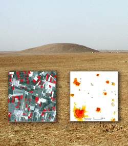
Researchers Jason Ur and
Bjoern Menze used computers
to analyze an ASTER image (left) of the Bronze Age city of
Hamoukar (ca. 2600 to 2000
B.C.), located in northeastern
Syria's Khabur Basin, to find
areas of human occupation
(right, indicated by orange
clusters). Their method allows
them to find smaller sites, in
addition to ones that form large
mounds. (Courtesy Jason Ur, Harvard University, and Bjoern Menze, Massachusetts Institute of Technology)
Since the early twentieth century, archaeologists
have relied on aerial photography as a technique
to locate possible sites without having to physically
survey vast areas. Signs of human habitation
in aerial photos derive from the presence
of habitation mounds and from changes in soil
color tied to the presence of anthrosols—soil that has been
modified by human activity.
While inarguably useful for finding sites, this type of remote
sensing analysis is time-consuming and tedious, requiring
researchers to pore over hundreds of images to identify potential
candidate sites for excavation. Further, only large mounds
are discernible in aerial photos. Thus, smaller sites are tough to
detect, the relationships between different settlements are hard to
decipher, and the expanse of a civilization is difficult to determine.
In order to fill in the blanks, archaeologist Jason Ur of
Harvard University and Massachusetts Institute of Technology
computer scientist Bjoern Menze have now turned the job of
image analysis over to computers. Their method uses images
taken by ASTER, the Advanced Spaceborne Thermal Emission
and Reflection Radiometer instrument aboard NASA's Terra
satellite, originally launched in 1999 to observe changes in the
Earth's climate. Their approach takes advantage of the fact that
anthrosols and the soil around them reflect light differently.
As a starting point, Ur and Menze focused on ASTER images
of the Early Bronze Age city of Hamoukar in northeastern Syria,
which Ur had surveyed intensively from 2000 to 2001. The
researchers identified and differentiated between "sites" and
"non-sites" in the ASTER images of the area. Thanks to the presence
of anthrosols in what had once been inhabited areas, sites in the images had a different spectral signature than non-sites.

To read more, find ARCHAEOLOGY in your local newsstand or bookstore, or click here to buy a copy of the issue online. And if you'd like to receive ARCHAEOLOGY in your mailbox, click here to subscribe.
Aldo Foe is an intern at ARCHAEOLOGY.