Discovering evidence of an ill-fated mission in the frigid waters of the Arctic
It was well past midnight this past July and the round-the-clock Arctic sun was shining on Mercy Bay. Exhausted Parks Canada archaeologist Ryan Harris was experiencing a rare moment of rest on the rocky beach, looking out over the bay's dark, ice-studded water. Around him, a dozen red-and-yellow tents lined the shoreline—the only signs of life. Every day for the previous two weeks, work had started by mid-morning and continued nonstop for 16 hours. Night and day had little relevance in the murky, near-freezing waters. Along with Parks Canada's chief of underwater archaeology, Marc-Andre Bernier, Harris has overseen more than 100 dives at this remote inlet of Banks Island in Aulavik National Park, exploring the wreck of HMS Investigator, a British vessel that has sat on the bottom of the bay for more than 160 years.
Harris and a small team of archaeologists had discovered Investigator in 2010 and returned in 2011 with a larger team to dive, study, and document the wreck, which holds a critical place in the history of Arctic exploration. Twenty-five feet below the surface, Investigator sits upright, intact, and remarkably well preserved. Silt covers everything below the main deck, entombing the officers' cabins, the ship's galley, and a full library. The archaeologists had intended to leave the wreck and its artifacts where they had lain since the polar ship was abandoned, trapped in ice, on June 3, 1853. Artifact recovery was not part of their original plan, but that plan changed after their
first few dives.
The team was instantly surprised by the number of artifacts they saw—muskets, shoes, and hunks of copper sheathing rested on Investigator's upper deck, dangled off the hull, or lay haphazardly on the sediment. Leaving these artifacts behind in Mercy Bay would have made them vulnerable to the icebergs that regularly scour the bay's floor, including the ones the sixman dive team had been dodging since their arrival.
Each piece fished from the water was a clue to life at sea aboard a ship during a period of British fervor for Arctic exploration. The captain of Investigator, Robert McClure, was originally sent to find and rescue two ships, HMS Erebus and HMS Terror, that Sir John Franklin had led into the Arctic in 1845 to discover the long-sought Northwest Passage connecting the Atlantic and Pacific oceans. Investigator's voyage ended, without sight or word of Franklin's ships or crew, when it was set upon by ice in Mercy Bay. After 39 months at sea, the listing ship sat, slowly being crushed on all sides, for three frigid years—with no Inuit encounters, no British search parties, and no relief. For much of that time, McClure and his crew of 60 were desperate and under constant threat of starvation, until a surprising rescue in the spring of 1853. Fifty-five men survived the ordeal.
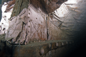
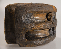
Archaeologists found much of the ship's protective copper sheathing, including numerals to indicate its load based on how low it sat in the water.
(Courtesy Parks Canada, Brett Seymour, NPS)
Visible sheathing was measured.
(Courtesy Parks Canada, Brett Seymour, NPS)
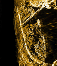
A sonar image shows the intact, iceberg-scoured wreck of
Investigator.
(Courtesy Parks Canada)
Among the artifacts retrieved was a long musket that may have belonged to one of the Royal Marines aboard the ship.
(Courtesy Parks Canada, Brett Seymour, NPS)
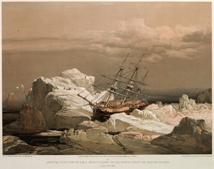 Investigator
 crewman Lieutenant Samuel Gurney Cresswell painted the ice-bound ship
(Lieutenant Samuel Gurney Cresswell, Courtesy Toronto Public Library)
In July 2010, after months of study to pinpoint Investigator's resting place, the actual discovery of the wreck took just a few minutes. Harris was in the bay in an inflatable boat testing sonar equipment when the wreck came into range. The four hours of video gathered on that trip showed that the ship was, in essence, frozen in time, protected by the cold water and opaque, light-blocking ice cover. It would be a year before they could return with cold-water diving equipment to have a closer, more detailed look. Over that year, the Parks Canada team pored over photographs and examined glowing gold ultrasound images that showed timber from the wreck scattered across the upper deck like matchsticks. They sought and received the blessing for a more intensive exploration of the wreck site from the 136 residents of Sachs Harbour, an Inuvialuit (Inuit from the western Arctic) community on the southwestern tip of Banks Island, the closest permanent community, some 125 miles away. In addition to the underwater work to document the wreck, archaeologist Henry Cary led a land-based survey and excavation team of Inuvialuit archaeologists, conservation officers, and park staff. It fell upon Cary to shuttle the 8,820 pounds of equipment up to the 74th parallel, including tents, a three-week supply of food, two boats, diving gear, compressors, recording equipment, surveying tools, and 20 barrels for collecting fresh drinking water.
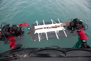
The archaeologists came prepared for delays, nasty weather, and polar bears—but they weren't prepared for the number of artifacts that needed recovery. Harris, Bernier, Cary, and their crews had packed cameras, lasers, and measuring tapes to document the sites but fewer items to help them retrieve, excavate, or transfer artifacts. Recovering the wreck's finds quickly used up their small toolkit for stabilizing artifacts: foam padding, tongue depressors, and gauze bandages.
"We had not really envisioned the number of artifacts that were visible and exposed on the deck. So, basically, we had to improvise,"
says Bernier.
Someone ripped the lid of a large black storage case off its hinges to use as a cradle to lift a bent and corroded musket from the frigid waters. A large food cooler was loaded with a shredded, twisted, oxidized sample of the copper sheathing used by the British navy to reinforce their Arctic fleet for contact with icebergs. To protect a fragile rectangle of encrusted felt—a novel addition to Investigator that was intended to keep the ship watertight—Harris fashioned a cover out of absorbent chamois, ripped up an old black T-shirt to place underneath it, and sandwiched the artifact between floorboards taken from the boat that had shuttled them between land and the wreck. The artifacts then made a more than 4,000-mile journey, by helicopter, Twin Otter plane, and commercial airliner, to the Parks Canada conservation lab in Ottawa, where they are being conserved and studied today.
Improvisation was also critical for McClure's Arctic odyssey, according to diaries and other accounts written by McClure and his crew. In January 1850, Investigator and the officers, sailors, and marines on board set sail from Devonport, England. But the ship lagged behind its traveling companion, HMS Enterprise, which cleared out resupply ports along the way. In Honolulu, McClure heard rumors that his mission would be called off if he continued to fall behind. So he made a gamble, abandoning the traditional 60-day route into the Arctic, and followed an untested course due north through the gauntlet of the Aleutian Islands. He trimmed a month from his journey.
McClure pushed into the Prince of Wales Strait, which separates Banks and Victoria islands, and then set off with a six-man crew across the ice on a sled, hoping to find a path through to the Northwest Passage. After days of travel, on October 26, 1850, his team spotted open water (now known as McClure Strait), and well-known Melville Island beyond. This was it: the Northwest Passage. But actually navigating the ship there would prove much more difficult. After McClure and his crew spent a winter stuck aboard Investigator in the Prince of Wales Strait, on the southeast side of Banks Island, McClure doubled back to circumnavigate the island in search of the open water he had seen from the sled. By the end of the summer of 1851, McClure had sailed into the strait that now bears his name and reached the Bay of God's Mercy (now Mercy Bay) on the north side of Banks Island, in the middle of the Northwest Passage. In the bay, ice set in and did not give way.
Almost immediately, the men were put on two-thirds rations, though they found deer and Arctic hare to hunt on shore. In the spring of 1852, McClure sent a sled team to seek assistance on Melville Island, but they found no provisions or sign of rescue. They left a message in the hope that search parties might visit there. Both health and spirits began to wane, but there were a few reasons for optimism. As the ship's supply of venison was depleted, Sergeant John Woon (later decorated for valor on the mission) felled two musk oxen—647 pounds of fresh meat. And as the symptoms of scurvy started to appear, they discovered a stash of wild sorrel and prepared salads to push
back the disease.
"This was a totally alien landscape to them and yet, at the same time, men at least 10 or 15 years younger than me had been to India, Australia. They had sailed all over the world. So the idea of a new landscape was nothing unusual for them," says Cary, who is 35. "But I think being stuck there would have played on their emotions."
McClure watched his men grow sicker and weaker. In September 1852, losing hope, he devised a plan to send half the crew away for a better chance at rescue, while he and the remaining 30 would wait in Mercy Bay for another year before abandoning the ship. At the same time, unbeknownst to McClure, HMS Resolute, another British polar ship, had arrived at Melville Island and had found the message McClure's crew left earlier that year, outlining Investigator's predicament and position. It was the first word anyone had received from McClure in years and reason enough to send a search party to Mercy Bay.
On April 7, 1853, as McClure prepared to send his teams out in search of help, the first of Investigator's crew succumbed to scurvy. McClure and his first lieutenant walked along the shores of Mercy Bay, trying to figure out how to dig a proper grave in the permafrost for Boatswain John Doyle. In the distance, they saw what McClure later described as an image of one of his own men being pursued by a bear. As the apparition approached, it took on the shape of Lieutenant Bedford Pim of Resolute.
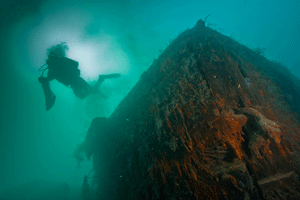
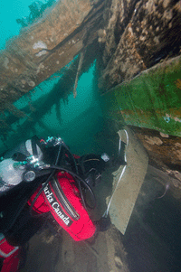
An underwater archaeologist floats beside the
Investigator wreck.
(Courtesy Parks Canada, Brett Seymour, NPS)
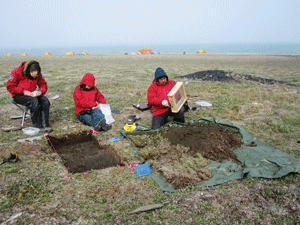
Archaeologists documented and excavated terrestrial sites, including McClure's cache, where the crew stashed supplies.
(Courtesy Parks Canada, John Lucas Jr.)
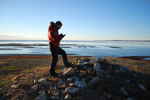
A stone cairn that the crew erected as a signal for passing ships.
(Courtesy Parks Canada, Edward Eastaugh)
"The heart was too full for the tongue to speak," McClure later wrote.
In July 2011, helicopter malfunctions kept Bernier, Harris, and the final load of equipment from reaching Mercy Bay for three days. For Harris, the logistical challenges were frustrating. For Bernier, they were agony. He had sat out the 2010 trip when Investigator was first discovered, so he was dying for a look at the wreck. A second aircraft was called in and finally got everyone and everything to camp. Harris and Jonathan Moore, a British-born underwater archaeologist, slipped into the water above Investigator for the first time at 10:22 p.m. to assess the site, check for safety hazards, and decide what could be done. In 2010, the water had been crystal clear, so the wreck was visible from the surface. This time the water was hazy and murky, perhaps because of heavy runoff from the melting snow and ice. The two divers could see only 10 or 15 feet in front of them.
"As we proceeded toward the hull, it gradually started to loom out of the haze," Harris says. "It's really an exceptional shipwreck to behold, just sitting in this stately fashion, upright on the sea floor. It's been heavily impacted by ice grinding down on top of it over the years, but it's held together impressively well. It's quite majestic."
While the divers explored the wreck, Cary led the search for remains of the McClure expedition on land. In 2010, his team had found a depot of supplies, known as McClure's cache, which the crew left on the shore of Mercy Bay as an insurance policy for waylaid sailors like themselves. In studying the cache, Cary was examining not only what materials McClure's men brought to the north and stashed, but also what items were taken (or left behind) by Inuits who later mined the cache for clothing, or materials for hunting and cooking.
The itemized list that McClure left at the site states there were seven pairs of boots in the cache. Of those, the soles of six pairs of those boots were left behind, unused by visiting Inuits. This suggested to Cary that the soles were of no practical use to the Inuit. By contrast, cans appear to have been coveted. Joe Kudlak, an Inuit patrolman with Parks Canada, found a tin can believed to have originated with Investigator a few miles south. An identical specimen was found at a kill site for musk oxen 15 minutes away by helicopter. Still others have been found cut up and refashioned by Inuit into blades and other cutting tools that incorporate bones, antlers, and other more traditional Inuit materials.
Cary also used the writings of Johann Miertsching, a Moravian missionary who had spent time with Inuit in Labrador and was part of Investigator's crew, to locate the whalebone remnants of a Paleoeskimo camp site dating back 2,500 years. A new translation of those writings, plus a magnetometer, which measures magnetic fields, also helped the team in 2010 find the graves of the three crew members who died at Mercy Bay. The bodies of John Eames, John Boyle, and John Kerr were all found lying in a north-to-south line facing east, in keeping with the Anglican tradition. Because of the permafrost, the earth at the graves was still raised. The graves might have been dug and filled in yesterday, Cary says, underlining for him the power and permanence of the Investigator story.
"It hasn't changed in 150 years. When you're standing at McClure's cache, the landscape that the men of Investigator would have looked out at from the ship and from the shore is exactly the same. There's been absolutely no change whatsoever," he says. "And when you're at the Paleoeskimo site, you realize there's been no change for 2,500 years."
In the 2011 field season, Cary and his crew strapped a high-resolution digital camera to the bottom of a helicopter and photographed the area with the goal of testing the accuracy of a topographic map made in 1853 by Stephen Court, the second master aboard Investigator. They also collected several terrestrial artifacts, including the head of a barrel believed to have belonged to the British military and a quartz knife made at the Paleoeskimo site.
"It was just sitting there," Cary says of the discovery. They also recovered a large bell-shaped iron truss, first located decades ago, that is believed to have supported Investigator's topsail. It was found on the beach, buried under loose rock on the shore. No one knows how it got there, but the clamp section, once round, is now oval—a testament to the crushing power of Arctic sea ice.
Archaeologists retrieved a double-sheave pulley from the ship's rigging
(Courtesy Parks Canada, Louis Barnes)
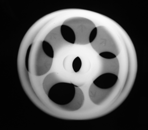
An X-ray of the artifact reveals the British broad arrow stamped onto the spokes of both of the pulley's brass sheaves.
(Courtesy Parks Canada)
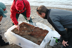
Archaeologists from Parks Canada, on the shore of Mercy Bay, examine the felt sheet recovered from the Investigator wreck site. A rare artifact, the hearty fabric was applied along the inside of Investigator's hull and beneath her upper deck to insulate the vessel and make her more watertight.
(Courtesy Parks Canada, John Lucas Jr.)
In the Ottawa laboratory where the materials recovered so far are being studied and analyzed, other rich stories of McClure's era and his adventures are emerging. The bent, broken, and corroded musket, for example, likely belonged to one of eight Royal Marines aboard the ship. The iron, copper, and wood specimen is still soaking in a bath of deionized water months after being recovered, but it's in good enough shape to see the markings on the butt plate. "1842, we believe, is the likely date of manufacture," according to Harris.
"It's kind of worn," says Parks Canada conservator Flora Davidson, who runs the chemical baths used to remove the saltwater from the artifacts and preserve the metals. Also visible is the marking "W&D," which the researchers believe shows that the owner of the gun was posted to the Woolwich Division of the Royal Marines, stationed at the Woolwich Dockyards in London.
"Possibly, the record might exist to attribute this particular weapon to an individual, which makes it kind of exciting," Harris says.
Each piece of copper sheathing affixed to the hull of Investigator is marked not only with its place and date of production, but also with a broad arrow, showing it to be property of the British navy. The same arrow shows up on fasteners, bolts, and the tiniest tacks, as well as on X-rays of a wooden rope pulley that Bernier raised from the wreck. Initially, the pulley was covered in mud, but after some cleaning, the archaeologists noticed that it also contained several strands of cord. The lab showed that the cord contained not just hemp, which was the primary choice of material for rope back then, but also wool—"Rogue's Wool," to be precise. They believe the fabric, now a muddy brown color, was originally red, identifying it as the official rope of London's Deptford Dockyard.
Also in the lab, in a shallow basin, is what Harris refers to as a "potentially one-of-a-kind artifact." Soaking in water in the basin is the gray, rectangular sheet of thick, coarse felt, stained with bright orange patches of rust and little bolt holes. Harris' black T-shirt, brought into service as a protective pad, peeks out from beneath it. The material is not unlike today's felt—a pressed textile—however, this sturdy stuff would have been used to waterproof ships. There are stories of damaged vessels limping back to England only to discover that their felt was all that had been keeping them afloat. Drawings of Investigator show that the felt was placed beneath the wood on the upper deck and all along the reinforced hull. This is a rare find, as few similar samples from the period have been discovered or preserved.
Under the microscope, the felt yields a particularly Canadian surprise. It is woven from the guard hairs of beaver pelts—known for their water resistant qualities—suggesting that at least one North American pelt had made a round trip to England and back again. Now the team at the Parks Canada lab is looking into how the textile was produced—by hand or machine—and examining the properties that made it so well suited to service in the Arctic.
"Not too many of these have been found, so we're, in a way, breaking new ground and asking questions that have never been asked before," says Bernier.
"Yeah," Davidson interjects. "You keep on bringing in these strange things, and when I consult my colleagues, they just say, �Good luck with that.'"
The ironies of Investigator's tale are that what began as a rescue mission required a rescue of its own, and that the expedition eventually achieved the tasks that had been set for Franklin and the now-lost HMS Erebus and HMS Terror (for which Parks Canada is also searching). However, Franklin and those earlier lost ships have long overshadowed McClure, his crew, and their accomplishments. The 55 members of Investigator's crew who returned home to England received a hero's welcome and a 10,000 pound reward—half for McClure and half distributed among the others. Despite their initial acclaim, their efforts were largely forgotten. The Investigator crew returned to a country that had largely tired of Arctic exploration. It was felt that these expeditions had eaten up too much time, too much money, and too many men. Perhaps a cold death might have secured them more enduring fame.
McClure and his crew, however, understood their achievement. It is known that while stuck in the ice, they celebrated every October 26 (when McClure first saw the strait now named after him) as the day that they had discovered the Northwest Passage. What's more, because they had entered the Northwest Passage from the west and were rescued from the east, those men were the first—by ship, foot, sled, and ship again—to make it all the way through the legendary northern route between the oceans.
"Our goal," Harris says, "is to remove Investigator from the margins of history."
 Video: Diving the HMS Investigator
 Slideshow: An Arctic Expedition in Watercolor
Allan Woods is a writer and reporter at the Toronto Star.