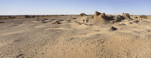
Many of the satellite images are mudbrick and stone castle-like structures built by the Garamantes civilization as many as 2,000 years ago.
(Copyright Toby Savage)
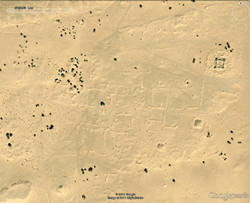
Researchers are using satellite images to identify archaeological features in the Libyan desert.
(Copyright 2011 Google, image copyright 2011 DigitalGlobe)
According to the fifth-century B.C. Greek historian Herodotus, the Garamantes, a civilization who inhabited the far reaches of the southwestern Libyan desert, were "a very great nation," colorfully described as hunting Ethiopians from chariots and herding "backwards-grazing cattle." Modern scholarship on the Garamantes has proceeded, but because of Qaddafi's suppression of Libya's pre-Islamic heritage, little to none has been published. Now, however, thanks largely to research conducted by a team led by David Mattingly of the University of Leicester, there is new evidence that the Garamantes were a highly sophisticated civilization who built state-of-the-art water extraction systems in the desert and constructed more than 100 fortified farms and villages, most dating to the first five centuries A.D. Many of these structures, some of which Mattingly calls "castle-like," are only now being identified with the aid of satellite images combined with on-ground photos and field surveys completed by Mattingly's team.
When the anti-Qaddafi revolt began, Mattingly was forced to leave Libya. He plans to return as soon as the country is safe and work with colleagues in the Libyan Department of Antiquities. At that time, his team's work will further explore and record evidence of a civilization who, according to Mattingly, were "pioneers in establishing oases and opening up the trans-Saharan trade" and are a crucial part of
Libya's history.